ROMS is a split-explicit, free-surface, topographic-following coordinate (or sigma-coordinate) model that is well suited to regional problems (see Shchepetkin and McWilliams, 2005 and Shchepetkin and McWilliams, 2008). It solves the incompressible primitive equations based on the Boussinesq and the hydrostatic approximations and is coupled with advection / diffusion schemes for potential temperature and salinity and a nonlinear equation of state. Shchepetkin and McWilliams (2003) and Shchepetkin and McWilliams (2005) provide a thorough description of the model formulation. The approximation of the horizontal pressure gradient force in topographic-coordinate models has been a long-standing problem due to hydrostatic inconsistencies that develop in the transformation of the horizontal pressure gradient terms in sigma-coordinate, hydrostatic primitive equation models. The error occurs when the discretized pressure gradient force fails to vanish with horizontal isopycnals, thus resulting in spurious geostrophically-balanced currents (Shchepetkin and McWilliams, 2003). From comparisons with a laboratory experiment, Kliem and Pietzak (1999) showed that this error was most significant in regions of steep topography and large density gradients. This issue was addressed by Shchepetkin and McWilliams (2003), who developed a new pressure-gradient algorithm, designed to reduce the pressure-gradient error, by achieving more accurate hydrostatic balance terms for the sigma-coordinate formulation. Their algorithm reconstructs the density field into z-coordinates as continuous functions of transformed coordinates and is then analytically integrated to compute the pressure-gradient force (Shchepetkin and McWilliams, 2003). The advection scheme is third-order upstream biased which reduces dispersion errors, based on excessive dispersion rates necessary to maintain smoothness. This essentially enhances the precision for a given grid resolution (Shchepetkin and McWilliams, 1998). The recent implementation of higher-order diffusive advection schemes has lead to spurious diapycnal mixing in sigma-coordinate models. A solution to this problem was addressed by Marchesiello (2009) and involves the split of advection and diffusion, the latter of which appears as a biharmonic operator.
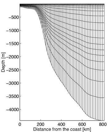
The figure on the left is an example of the terrain-following coordinate system used in ROMS
ROMS was first used to model the ocean around South Africa by Penven (2000) in order to investigate the transport processes of fish eggs and larvae from their spawning ground to the nursery area of St. Helena Bay in the southern Benguela region. His configuration consisted of a pie-shaped grid that followed the southwest corner of Africa (from 28°-40°S and from 10-24°E) that had a horizontally variable resolution, with higher resolution closer to the coast (18 km and 9km for the lower and higher resolution runs respectively). This configuration was named 'PLUME' and for the first time, allowed for the successful resolution of nearshore circulation features that are important to the ecological functioning of the southern Benguela system. As such it has been used in several physical-biological coupled model studies.
More recently, a regional study of the equilibrium dynamics of the entire Benguela Current system has been carried out using the 2-way nesting capability of ROMS (Veitch, 2009). The Benguela upwelling region was nested within the SAfE domain (Penven, 2006) at a resolution of 1/12° (~9 km), the latter providing boundary conditions for the former. The aim of this study was to systematically investigate the apparently disparate northern and southern Benguela regimes using spatially and temporally cohesive model data. The role of the Agulhas Current on the Benguela system was also of key interest and was investigated by constructing a dam off the east coast of South Africa in the model that removed the influence of the Agulhas Current on the west coast of southern Africa. ROMS has also been used by Chang (2009) to study dynamic features of the Agulhas Bank and, in particular, the cool ridge.
Above is an animation of sea surface temperatures simulated in ROMS for the Benguela upwelling system.
References:
Chang, N. (2009). Numerical ocean model study of the Agulhas Bank and the Cool Ridge. PhD thesis, University of Cape Town, South Africa.
Kliem, N. and Pietrzak, J. (1999). On the pressure gradient error in sigma coordinate ocean models: A comparison with a laboratory experiment. J. Geophys. Res., 104(C12).
Marchesiello, P., Debreu, L., and Couvelard, X. (2009). Spurious diapycnal mixing in terrain-following coordinate models: advection problem and solutions. Submitted: J. Phys. Oceanogr.
Penven, P. (2000). A numerical study of the Southern Benguela circulation with an application to sh recruitment. PhD thesis, University of Brest.
Penven, P., Chang, N., and Shillington, F. A. (2006). Modelling the Agulhas Current using SAfE (Southern Africa Experiment). Geophys. Res. Abstr., 8(Abstract 04225).
Shchepetkin, A. and McWilliams, J. (1998). Quasi-monotone advection schemes based on explicit locally adaptive dissipation. Mon. Wea. Rev., 126:15411580.
Shchepetkin, A. and McWilliams, J. (2003). A method for computing horizontal pressure-gradient force in an oceanic model with a nonaligned vertical coordinate. J. Geophys. Res., 108(C3):3090.
Shchepetkin, A. and McWilliams, J. (2008). Handbook of numerical analysis: Computational methods for the ocean and atmosphere., chapter Computational kernel algorithms for ne-scale, multi-process, long-term oceanic simulations, pages 119181. Elsevier Science.
Shchepetkin, A. F. and McWilliams, J. C. (2005). The regional ocean modeling system (ROMS): A split-explicit, free-surface, topography-following-coordinate oceanic model. Ocean Model., 9:347404.
Veitch, J.A., P. Penven and F.A. Shillington (2008): The Benguela: a laboratory for comparative studies. Progress in Oceanography, doi: 10.1016/j.pocean.2009.07.08.